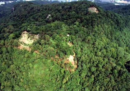
시도지정 및 문화재자료는 각 지자체 담당부서에서 문화재정보를 입력·수정 관리하고 있습니다.
문의사항이 있을 경우, 아래 지자체 담당부서로 연락하시기 바랍니다.
· 상 세 문 의 : 경기도 의왕시 문화체육과 031-345-2534
의왕시 오전동과 내손동의 경계지점에 있은 해발 385m 모락산에 있다. 이곳은 한성에서 수원-화성으로 가는 교통의 요충지이다. 모락산 정상부에서는 군포-안양-과천 일대가 넓게 조망되고, 주변에 넓은 평야가 배치되어 있어 행정중심지로 기능할 수 있는 위치다.
성벽은 몇 개의 봉우리를 감싸 안도록 축조되었으며 평면 형태는 부정형의 다각형이다. 토성이며 전체 둘레는 878m로 비교적 큰 규모에 속한다. 성벽은 흙으로 쌓은 구간이 대부분이지만, 석재가 사용되거나 성벽을 쌓지 않은 구간도 확인된다. 토성구간은 판축공법이 적용되지 않고 성토하여 구축한 것으로 보인다. 흙으로만 쌓기 어려운 구간은 석재를 보강했으나 가공되지 않은 할석이 상용되어 성벽이 정연하지 않다.
성벽에서는 문지 2개소와 치, 건물지 등이 확인된다. 성내에서 출토되는 유물은 대부분 백제토기편이다. 성벽을 성토다짐하여 쌓고 일부 구간에 가공하지 않은 석재를 사용하는 축성법 등은 포천 고모리산성, 파주 월롱산성 등과 유사하다. 이러한 축성법이나 출토유물을 고려할 때 모락산성은 백제성이다. 축성 및 사용 시기는 4세기 후반에서 5세기 중후반 경으로 추정되고 있다. 모락산성은 한성시기(BC18-AD475) 백제의 방어체계와 백제 산성의 축성법을 알게 해주는 중요한 유적이다.
This fortress is located on Moraksan Mountain at an altitude of 385m at the boundary between Ojeon-dong and Naejdon-dong of Uiwang-si. This place is an important traffic center between the capital and the regions of Suwon and Hwaseong. On the peak of Moraksan Mountain, there is a wide field that offers a view of Gunpo, Anyang, and Gwacheon and serves as the center of administration.
The city walls are constructed to embrace a few peaks, and the flat shape is an indeterminate polygon. The total circumference is 878m, which is on the larger side. The city walls are mostly built with clay, but sections that use stone or without walls were occasionally discovered as well. The earthen fortifications appear to have been built through piling soil without applying the technique of piling and packing soil for reinforcement. Sections that are difficult to pile with soil alone were supplemented with stone materials, but unpolished split stones were used, making the wall look disorderly.
Two door sites, chi (a protruding structure for observing the approaching enemy and defeating those who approach from the front or side), and building site were confirmed on the city wall. Artifacts excavated from the castle were mostly Baekje earthenware fragments. The castle-building technique of piling and packing soil and using unpolished stone materials in certain sections is similar to that of Gomorisanseong Fortress in Pocheon and Wollongsanseong Fortress in Paju. In consideration of this castle-building technique and excavated artifacts, the Moraksanseong Fortress is thought to be a castle from the Baekje Period. The period of construction and use is estimated to be between the late 4th century and mid to late 5th century. Moraksanseong Fortress is an important historic site that sheds light on the defense system of Baekje and its castle-building technique for fortresses during the Hanseong Period (18 BC – 475 AD).
该山城位于义王市五全洞和内荪洞交界处(海拔385米)的慕洛山上。此处是汉城去往水原华城的交通要塞。站在慕洛山山顶,可以眺望军浦、安养、果川一带,周围是广袤的平原,地处可以发挥行政中心职能的位置。
城墙围住了几座山峰,平面形态呈不规则的多边形。山城为土城,总长为878米,属于大型规模。城墙大部分用土砌成,但也有使用石材或未砌城墙的部分。土城部分用堆砌垫高的土建成,未采用版筑工法。对于无法只用土垒砌的部分,则使用石材进行加固,但使用的都是未加工的切割石,所以城墙并不整齐。
城墙上有雉、建筑遗址及两处门址等。城内出土的文物大多是百济陶器。夯实堆砌垫高的土垒成城墙,部分城墙使用未加工石材的筑城法等,与抱川古毛里山城、坡州月笼山城等类似。从这种筑城法及出土文物推测,慕洛山城应该是百济城,筑城及使用时期是4世纪后期至5世纪中后期左右。慕洛山城属于重要遗迹,可从中窥见汉城时期(BC18-AD475)百济的防御系统与百济山城的筑城法。
ウイワン(義王)市オジョン(五全)洞とネソン(内蓀)洞の境界点にあるモラクサン(慕洛山、海抜385m)の山頂付近に位置する。ここはハンソン(漢城)からスウォン(水原)~ファソン(華城)までつながる交通の要衝である。モラク(慕洛)山の頂上からはクンポ(軍浦)~アニャン(安養)~クァチョン(果川)一帯を広く眺望でき、周辺に広い平野が広がっており、行政の中心地としての機能を果たすことができる。
城壁はいくつかの峰を包み込むように築造されており、平面形態は不定形の多角形だ。土城であり、円周の長さは878mで比較的大きな規模に属する。城壁は土で築いた区間がほとんどだが、石材が使われた部分や、城壁を築いていない区間も確認できる。土城の区間は版築工法は適用されず、盛土して構築したものとみられる。土だけで築くのが難しい区間は石材で補強したが、割石(割ったまま加工していない石)が常用され、城壁が整然としていない。
城壁では2箇所の門跡と雉(城壁に付属した小さな垣根)、建物跡などが確認できる。城内で出土する遺物はほとんどが百済の土器片だ。城壁を盛土で固めて積み上げ、一部区間に加工していない石材を使用する築城法などはポチョン(抱川)コモリ(古毛里)山城、パジュ(坡州)ウォルロン(月籠)山城などと類似している。このような築城法や出土遺物から、モラク(慕洛)山城は百済の城であることが分かる。築城年代・使用時期は4世紀後半から5世紀中頃と推定されている。モラク(慕洛)山城は漢城時代(BC18~AD475)、百済の防御体制と百済山城の築城法を知る上で重要な遺跡である。