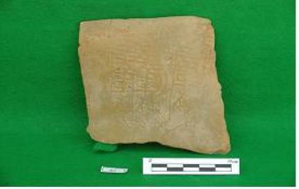
시도지정 및 문화재자료는 각 지자체 담당부서에서 문화재정보를 입력·수정 관리하고 있습니다.
문의사항이 있을 경우, 아래 지자체 담당부서로 연락하시기 바랍니다.
· 상 세 문 의 : 경기도 평택시 문화예술과 031-8024-3249
평택시 안중읍 용성리의 해발 102.2m인 비파산에 있다. 비파산은 산세가 비파악기를 닮았다고 붙여진 이름이다. 이곳은 동쪽으로 차령산맥, 남쪽으로 아산만 일대, 서쪽과 북쪽으로는 서해안 일대가 조망되는 전략적 요충지다.
산성은 비파산의 정상부와 용성리 뒷골의 평지를 포함하는 삼태기 모양의 평산성이다. 성벽의 둘레는 1,622m로 인근의 성곽 중에서는 가장 규모가 크다. 발굴조사 결과 성벽은 판축공법으로 쌓은 토성으로 확인되었다. 성벽의 기초를 정지하고 일정한 간격으로 기단석열을 배치한 후 점질토와 사질토를 교대로 쌓는 판축공법으로 중심토루를 먼저 구축했다. 이후 중심토루 내외의 기저부에 와적층을 깔고 내피토루와 외피토루를 덧붙여 쌓아 토성을 구축했다. 성벽이 돌아가는 부분에는 외부로 돌출된 치를 설치했으며, 4개 정도의 성문 있었던 것으로 보인다. 이러한 축성법은 통일신라 말기부터 등장하며, 성벽에서 출토되는 유물의 양상으로 보아 비파산성은 고려시대 초기에 쌓은 것으로 보인다. 성벽을 쌓은 흙 속에서 ‘건덕3년(乾德三年)’명 기와가 출토되어 965년 고려 광종 16년 이후에 축성되었다는 것을 말해준다.
통일 신라 시대에 거성현으로 불리었던 평택지역은 고려시대에 용성현(龍城縣)으로 개칭되었다. 고려 시대에는 치소성의 위치도 산성에서 평지성으로 옮겨진다. 따라서 자미산성에 있던 거성현의 치소를 비파산성으로 옮겨 용성현의 치소로 삼았던 것으로 보인다. 성내에서 ‘거성(車城)’명 기와가 출토되는 것으로 보아 용성현으로 개칭된 이후에도 한동안 거성현으로 불렸음을 알 수 있다. 비파산성은 통일신라에서 고려 시대의 치소성이 석성에서 토성으로, 산성에서 평산성으로 변화되었음을 입증해주는 중요한 유적이다.
This fortress site is located on Bipasan Mountain (alt. 102.2 m) in Yongseong-ri, Anjung-eup, Pyeongtaek-si. Bipsan Mountain was named for its shapes, which resembles a bipa (a type of stringed instrument). The fortress and surrounding region was a strategic hub with a good view of the Charyungsanmaek Range to the east, Asanman Bay to the south, and the west coast to the north and west.
The fortress is a flat, semi-circular fortress that encircles Bipasan Mountain and plains at the back of Yongseong-ri. The circumference of the wall is 1,622 m, which is the largest of the castles in the region. Excavation results have shown that the wall was built using the panchukgongbeop technique (technique of strengthening a structure by piling and packing soil) . The central structure of the fortress was made by evening out the wall, placing rows of stylobate stones at regular intervals, and alternatively piling up clay and sandy soil. The structure was completed by laying layers of roof tile along the inner and outer bases, and piling up inner and outer protrusions. Part of the wall was installed with a chi (a protruding structure for observing and fighting off enemies from the front and sides), and there appears to have been four gates. This fortress-building technique used here emerged sometime during the Late Unified Silla Period, and judging by the artifacts excavated from the walls, Bipasanseong Fortress appears to have been built in the Early Goryeo Period. A roof tile with the inscription “Geondeok, 3rd year” was excavated from the walls, revealing that the fortress was built after 965, during the 16th year of King Gwangjong’s reign of the Goryeo Dynasty.
Pyeongtaek, which was renamed Geoseong-hyeon during the Unified Silla Period, was called Yongseong-hyeon in the Goryeo Period. During the Goryeo Period, the fortress was also moved from a mountain location to a flat location. The defense fortress of Geoseong-hyeon in Jamisanseong Fortress appears to have been moved to Bipasanseong Fortress and was used as the defense fortress of Yongseong-hyeon. Judging from the fact that the roof tile inscribed with “Geoseong” was excavated from inside the castle, it is evident that the place was called Geoseong-hyeon for some time, even after the name was changed to Yongseong-hyeon. Bipasanseong Fortress is an important historic site that chronicles how defense fortresses changed from stone fortresses to earthen fortresses from the Unified Silla to the Goryeo Period, and from mountain fortresses to fortresses located in flat areas.
位于平泽市安仲邑龙城里海拔102.2米的琵琶山上, 因山势形似乐器琵琶,故而得名琵琶山。这里是战略性要地,东侧有车岭山脉、南侧有牙山湾一带、西侧和北侧可以眺望西海岸一带。
山城是形似簸箕的平山城,包括琵琶山山顶和龙城里后谷的平地。城墙周长为1622米,在附近城郭中规模最大。从发掘调查结果来看,该城墙为使用版筑工法建造的土城。将城墙地基处理平整,按照一定间隔放置基坛石列后,采用交替堆砌黏质土和沙质土的版筑工法先建造中心土垒,之后在中心土垒内外基部铺设瓦积层,然后叠加内层土垒和外层土垒建造成土城。在城墙拐弯的地方,设置了向外突出的“雉”,据推测这里原来约有四个城门左右。这种筑城方法从统一新罗末期开始出现,从在城墙中出土的文物样式来看,可推测出琵琶山城建于高丽时代初期。在堆砌城墙的泥土中,出土了“乾德三年”铭瓦,这表明城墙建于高丽光宗16年(965年)以后。
统一新罗时代,平泽地区被称为车城县,高丽时代更名为龙城县。高丽时代,治所城的位置也由山城搬迁至平地城。因此,原来位于兹美山城的车城县治所搬迁至琵琶山城,并视为龙城县的治所。从在城内出土的“车城”铭瓦来看,可以得知这里在更名为龙城县以后,也有一段时间被称为车城县。从统一新罗到高丽时代,治所城从石城变为土城、从山城变为平山城,琵琶山城正是可以证明这种变化的重要遗迹。
ピョンテク(平沢)市アンジュン(安仲)邑ヨンソン(龍城)里のピパ(琵杷)山にある。海抜は102.2mだ。ピパ(琵杷)山は、山の形が楽器の琵琶に似ていることから付けられた名前だ。ここは東にチャリョン(車嶺)山脈、南にアサン(牙山)湾一帯、西と北に西海岸一帯が眺望できる戦略的要衝である。
山城はピパ(琵杷)山の頂上部とヨンソン(龍城)里の裏谷にある平地を含む。箕の形をした平山城だ。城壁の長さは1,622mで、近隣の城郭の中では最も規模が大きい。発掘調査の結果、城壁は版築工法で築いた土城であることが確認された。城壁の基礎を整えた後、一定の間隔で基壇石列を配置し、粘質土と砂質土を交互に積み上げる版築工法で中心の土塁を先に構築した。その後、中心の土塁内外のの基底部にの瓦積層を敷き、内側土塁と外側土塁を重ね上げて土城を築いた。城壁が曲がる部分には外部に張り出した垣が設けられており、4つほどの城門があったと推定される。このような築城法は統一新羅末期から登場している点や、城壁から出土する遺物の様相から、ピパ(琵杷)山城は高麗時代初期に築かれたものと考えられる。城壁を積んだ土の中から「乾德三年」と刻まれた瓦が出土し、965年、高麗光宗16年以降築城されたことを物語っている。
統一新羅時代にコソン(車城)県と呼ばれたピョンテク(平沢)地域は高麗時代にヨンソン(龍城)県に改称された。高麗時代には治所城の位置も山から平地に移った。つまり、チャミ(玆美)山城にあったコソン(車城)県の治所をピパ(琵杷)山城に移し、そこをヨンソン(龍城)県の治所としたというわけだ。城内から「車城」銘の瓦が出土していることから、ヨンソン(龍城)県に改称されてからもしばらく「コソン(車城)県」と呼ばれていたことが分かる。ピパ(琵杷)山城は統一新羅~高麗時代の治所城が石城から土城に、山城から平山城に変化したことを立証する重要な遺跡である。